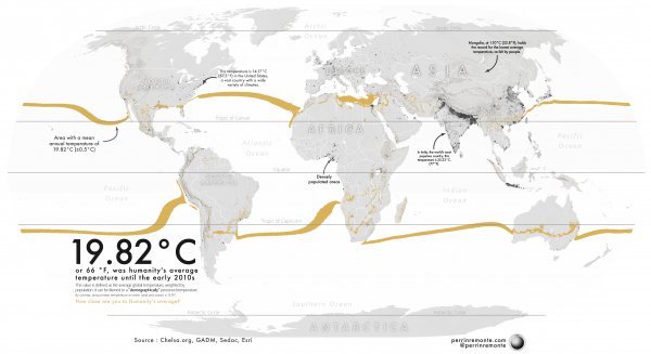
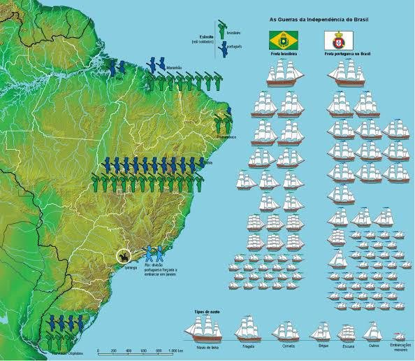
Map of troop deployments and naval strength of both sides at the outbreak of the Brazilian War of Independence, which began September 7th 1822

Although not as large as the wars in independence in the United States and Spanish colonies, the Brazilian War of Independence still saw combat break out across the country between troops loyal to Portugal and troops loyal to the newly proclaimed Empire of Brazil. Fighting was concentrated in the provinces of Bahia, Piauí, Maranhão and Cisplatina.

image
Read also:

Where International Students in the U.S. Come From

https://www.visualcapitalist.com/cp/international-students-in-the-u-s-come-from/

image

Mapping Humanity's average temperature : how close do you live to the average ? [OC]

image

rise and fall of the eastern rome

image

Just a map of Italy (by Maps International)

image

What % of the people in each Indian province are 'poor'?

image

300 Inch Map Of The Moon | Hugh Percy Wilkins 3rd Edition (1951)

image

2020 world population density map

image

“Portugal Is Not a Small Country

image

Spain and the Spanish Indies.

image

The Empire of Timur the Lame, c. 1404 CE

image